
In the interests of others that wonder about the relative elevation profiles of marathons I have blown them up in Garmin and screen shot them and post them here.
One of the problems with Marathons is that they DON'T post this data. Instead they usual use the MapMyRun site or some other data which is very filtered and compressed so that you really can't get the information you want.
So here they are: elevation profiles from several of the road marathons I've run. Note that the left scale is different for each one so be careful when comparing by eye..take a note of how big 100' of change is!
If you want to read the race report for any of these races go here.
San Francisco Marathon Elevation Profile

The SFM data has problems with the bridges so you need to ignore the weird stuff starting at mile 6 or so and ending at mile 9. Remember this data comes from radar data and the radar does not see the bridge decks (too narrow) , so the elevation drops to 0 or even below zero (due to some filtering artifacts probably).
But you get the Idea: SFM is hilly at mile 5 you climb a very steep hill about 180' up to the bridge area. The bridge itself has a nice crown on it that goes up about 50' that you run over twice. The Garmin reports this as 1700' of up and down, I would subtract off about 650' from the bridge errors give us a total of 1100'. There are a lot of steep downs that you can't run well.
They play on this by calling it the "Race even Marathoners Fear". I fear it because it is so effing crowded, especially on the bridge deck.
But if you've never run it you should do it once. Touring SF by foot in a Marathon is a lot of fun and where else can you run in 55F fog in the middle of summer in the USA?
California International Marathon (CIM) Elevation Profile

CIM is a point to point, net down course and it has only one bridge just before mile 22 making that little downward blip you see. The Garmin calls this 400 up, 730 down. There is one big down-up at about mile 11. The race becomes very smoothly flat at about mile 22 just when you need that.
In 17 Marathons so far this is the fastest course as far as I am concerned.
Eugene Marathon Course Elevation Profile

The Garmin calls this one 380' of up-down and I think thats about right. There are some bridges but they are not high above the water compared to SF and so the data is pretty close as is.
You can see there are a couple of hills early on that are a bit nasty and there is the gradually , lumpy rise to the finish which was really tough for me. This is my current PR course (by about 1min 30s over CIM). I ran it right after CIM so I was in very good condition.
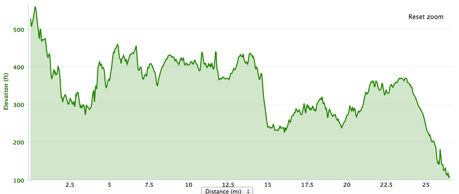
Tacoma City Marathon Course Elevation Profile

I knew about the huge up after the bridge, but I was kind of surprised by the number and size of the hills from mile 13 to mile 20...the website profile made these hard to see. The steep down at miles 16 and 19 (and many others) are not runnable...you don't get much out of it except sore quads.
The last 6 miles has two overpass climbs that kind of show up but look spiky which they are not. There is a gradual climb the last mile and then a swooping down to the finish.
However, like SFM it's a beautiful course and it is well run and NOT crowded so as long as you aren't PR hunting I think this is a more fun course than SFM.
Los Angeles Marathon Course Elevation Profile
Surf City Marathon Course Elevation Profile

Surf City can be foggy on race morning and that is what you are hoping for, but when the fog finally breaks it may get very warm quickly. As I recall they start the halfers a hour after the full which is really nice.
Long Beach Marathon Course Elevation Profile

Berlin Marathon Course Elevation Profile

The Garmin reports this course as 500' of up/down but we have some funny spikes that are probably road flyovers with tunnels we ran through or something like that so it's probably more like 400'. Frankly the hills are not very noticeable, but the CROWDS are.
I was pacing my friend for a 4:30. Back there it was crowded the entire marathon in a way I have never experienced before. I'm told that if you are in the 3:30 crowd or faster, it's not so bad and there you may have a PR course.
But hey, it's one of the majors and Berlin is a awesome city to visit so do this one sometime in your life if you get a chance!
Copenhagen Marathon Course Elevation Profile

This race is PR-able..there are some little ups and downs but not much and all runnable. The weather is most likely not hot in May (but with the wonky weather these days your mileage my vary 8/).
There are some bridges and tunnels but so there is probably about 450' of up/down at most. The course does have a lot of twists and turns so you have to pay attention to run the tangents. And there is a bit of crowding here and there...avoid the first water stop!
Great post Paul. A lot of your posts are really technical but I really enjoyed this one. I'm going to have to get out to CA to run.
ReplyDeleteSexy!! :)
ReplyDeleteI would love to run SF again. Someday.
this is a fantastic post. If I'm every able to run one of the marathons above I'll be sure to reference this post!
ReplyDeleteLong Beach Marathon will start hour earlier than the halfers this year. This will solve the crowding on the beach walk.
ReplyDeleteVery interesting, thanks! I must admit here in SA we have a yearly book Runner's Guide) that gives superb info including profiles of nearly all important races. We also have a few forums where info is brilliant. Race organizers are slowly realizing that they need to have profiles as part of the descriptions.
ReplyDeletethanks Paul - just doing a bit of research for Berlin and found your site - thanks for the info, i am really looking forward to the marathon in a few weeks.
ReplyDeleteHey thanks. Nice to know it was useful...
DeleteEnjoy Berlin and have a great race!
Hello Paul,
ReplyDeleteWould you mind posting the course elevation chart for the Paris Schneider Marathon? Thanks, Hans
No can do! These profiles are from races that I've run with my Garmin.
DeleteI've not run Paris yet (hope to someday!) so no data.
Thank you so much for posting this. I'm considering running San Francisco and I was trying to see how it's hills compared to those in the Tacoma City Marathon which I ran in 2008. Found another post where they described Tacoma as having "rolling hills." I'm definitely feeling less apprehensive about running SF after seeing your thoughts on Tacoma. =)
ReplyDeleteTacoma in 2008 was even WORSE than the Tacoma course you see above. SF is not a PR course but it's not anywhere near as bad!
DeleteSee you in SF!